Runoff and sediment budgets, Tijuana
This EPA-funded project (2014-2018) mapped and modeled runoff and sediment loads from Los Laureles Canyon (Goat Canyon) . Continuing work uses geochemical methods to trace sediment sources. Methods used included 3D imaging of stream channels, drones to map gully formation, measurement of discharge and sediment load, rainfall simulations, and modeling of hillslope (AGNPS) and channel processes (CONCEPTS). Students involved: K. Taniguchi (PhD, 2018), Napoleon Gudino-Elizondo (PhD 2018), Emily Perkins (MS 2010). * indicates a student co-author.
*Gudino-Elizondo N, *Brand MW, Biggs TW, Hinojosa-Corona A, Gómez-Gutiérrez Á, Langendoen E, Bingner R, Yuan Y, Sanders BF 2022. Rapid assessment of abrupt urban mega-gully and landslide events with structure-from-motion photogrammetric techniques validates link to water resources infrastructure failures in an urban periphery. Nat Hazards Earth Syst Sci 22:523–538. doi: 10.5194/nhess-22-523-2022
Biggs, T., *Zeigler, A., & *Taniguchi-Quan, K. T. (2022). Runoff and sediment loads in the Tijuana River: Dam effects, extreme events, and change during urbanization. Journal of Hydrology: Regional Studies, 42, 101162. https://doi.org/10.1016/j.ejrh.2022.101162. Original dataset at: https://www.hydroshare.org/resource/d2f319994a0e4a07ac0b09dcdff4bb61
Gudino-Elizondo N, Biggs TW, Bingner RL, Langendoen EJ, Kretzschmar T, Taguas E V, Taniguchi-Quan KT, Liden D, Yuan Y (2019) Modelling Runoff and Sediment Loads in a Developing Coastal Watershed of the US-Mexico Border. Water 11:1024. doi: 10.3390/w11051024
Gudino-Elizondo, N., Biggs, T., Bingner, R., Yuan, Y., Langendoen, E., Taniguchi, K., Kretzschmar, T., Taguas, E., & Liden, D. 2018. Modelling Ephemeral Gully Erosion from Unpaved Urban Roads: Equifinality and Implications for Scenario Analysis. Geosciences, 8(4), 137. http://doi.org/10.3390/geosciences8040137
Gudino-Elizondo, N., Biggs, T. W., Castillo, C., Bingner, R. L., Langendoen, E. J., Taniguchi, K. T., Kretzschmar, T., Yuan, Y., & Liden, D. 2018. Measuring ephemeral gully erosion rates and topographical thresholds in an urban watershed using unmanned aerial systems and structure from motion photogrammetric techniques. Land Degradation & Development. http://doi.org/10.1002/ldr.2976
Taniguchi, K. T., Biggs, T. W., Langendoen, E. J., Castillo, C., Gudino-Elizondo, N., Yuan, Y., & Liden, D. 2018. Stream channel erosion in a rapidly urbanizing region of the US-Mexico border: documenting the importance of channel hardpoints with Structure-from-Motion photogrammetry. Earth Surface Processes and Landforms. http://doi.org/10.1002/esp.4331
Biggs, T. W., Taniguchi, K. T., Gudino-Elizondo, N., Langendoen, E. J., Yuan, Y., Bingner, R. L., & Liden, D. 2018. Runoff and sediment yield on the US-Mexico border, Los Laureles Canyon, EPA/600/X-18/0XX. United States Environmental Protection Agency, Washington, D.C. https://cfpub.epa.gov/si/si_public_record_Report.cfm?dirEntryId=343214&Lab=NERL
Here is a video showing a 3D reconstruction of a 200m-long channel in Tijuana, created by Kris Taniguchi:
Here is a demonstration of surveying a channel using a GoPro camera mounted on a painter’s pole. The data from this was used to generate the model in the video above.
Rainfall simulations for modeling runoff and sediment
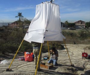 Rainfall is the most important driver of watershed processes, but storm events are infrequent and unpredictable in southern California, making rainfall simulation an attractive alternative for measuring surface processes like runoff and sediment production. Part of the EPA-funded project included development and use of a portable rainfall simulator on natural and disturbed soils in San Diego, coupled with modeling with KINEROS and AGNPS to quantify the impact of humans on watershed processes. Students involved: Chris Paulino, Hannah Carney, Garrett McGurk, John Estrada.
Land cover and socioeconomic status, 2008-2010
Funded by Southwest Consortium on Environmental Research and Policy (SCERP), US EPA,
This project aimed to map land cover and its relationship to socioeconomic status in Tijuana.
Biggs, T. W., Anderson, W. G., & Pombo, O. A. 2014. Concrete and Poverty, Vegetation and Wealth? A Counterexample from Remote Sensing of Socioeconomic Indicators on the U.S.–Mexico Border. The Professional Geographer, 1–14. http://doi.org/10.1080/00330124.2014.905161
Biggs, T. W., Atkinson, E., Powell, R., & Ojeda-Revah, L. (2010). Land cover following rapid urbanization on the US–Mexico border: Implications for conceptual models of urban watershed processes. Landscape and Urban Planning, 96(2), 78–87. http://doi.org/10.1016/j.landurbplan.2010.02.005
Other links:
Tijuana River Discharge Data: https://waterdata.ibwc.gov/
Tijuana Estuary Data Portal: tijuanariver.trnerr.org