For a full list of all papers, see Google Scholar page here or Biggs cv here.
Research interest form: For SDSU students interested in working with the Biggs Lab, please fill out the form here.
Current research projects
Rural Heat Islands and Farmworking Communities
Urban heat islands have received much attention in climate change adaptation, but mapping and adapting to rural heat islands (RHIs) is also critical for California’s climate action and environmental justice. Farmworking communities are vulnerable to heat stress, especially in the hot desert of the Imperial Valley.
We propose to map rural heat islands and to co-produce knowledge on heat stress exposure and dissemination strategies with the farmworker community of Imperial Valley, California.
Automated mapping of cropping intensity at global scales
This USGS-funded project (PI Dr Prasad Thenkabail) aims to map cropping intensity (single, double, triple cropping) at global scales using Google Earth Engine and machine learning techniques.
*** Seeking PhD and MS students for this project! Please contact tbiggs@sdsu.edu for details. ***
Sustainable agriculture and water in California
This USDA-funded project NextGen (PI Dr. Lluvia Flores-Renteria, Biology) aims to recruit students for the agricultural workforce and provide skills in sustainable agriculture. The water resources component focuses on irrigated agriculture and the water use of different crops in California using remote sensing and water balance methods.
*** Seeking BA/BS and MS students for this project! Please contact tbiggs@sdsu.edu for details. ***
Real-time Water Quality Monitoring
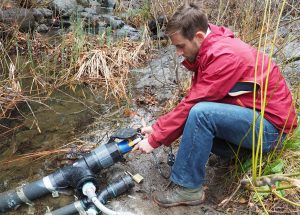
Impaired water quality threatens human health and ecosystems. Contamination events, including from sewer system overflows, can be difficult to predict, and yet there are few real-time water quality monitoring stations in the San Diego-Tijuana Border region. We are developing systems to monitor water quality in real-time, including proxies for bacteria concentrations, using telemetry and advanced water quality monitoring systems. See the Online Data and Summary Story. In 2019 we installed a system on the San Diego River at Mission Trails and in 2021 in the Tijuana Estuary to monitor tryptophan, an indicator of bacteria. See the data collected to date at http://sdwaterquality.sdsu.edu/.
Research tools and Datasets
SDSU General Guidelines for research safety here.
SDSU guidelines for safety in field research here.
PolicyMap: national datasets including census data (population, income, education), flood maps, etc.
EPA GeoPlatform.
Prior research
Click here to see prior research projects, including groundwater quality in the Imperial Valley, mapping socioeconomic conditions along the US-Mexico border, and others.